Places
Rajanpur
About this place
Rajanpur is one of the southernmost districts of Punjab and an important part of the Saraiki cultural region. Situated between the Indus River and the Sulaiman Mountains, the district brings together riverine plains, fertile agricultural land, mountain valleys, hill torrents, desert-edge landscapes and a rich tradition of Saraiki language, poetry, Sufi culture and tribal heritage.
GEOGRAPHY & LOCATION
Rajanpur District lies in the southwestern part of Punjab. The Indus River forms much of its eastern boundary, while the Sulaiman Mountain Range extends along its western side.
The district is connected geographically with Dera Ghazi Khan to the north, Muzaffargarh and Rahim Yar Khan across the Indus to the east, Sindh to the south and Balochistan to the southwest.
The district has three main tehsils:
• Rajanpur
• Jampur
• Rojhan
A large tribal or de-excluded area also extends into the Sulaiman Mountains.
RAJANPUR CITY
Rajanpur city is the administrative headquarters of the district.
The town was founded by Sheikh Rajan Shah around 1732–33 and subsequently became an important administrative centre.
Today, Rajanpur combines government offices, traditional markets, residential neighbourhoods, educational institutions and commercial areas with the agricultural communities surrounding the city.
HISTORY & FOUNDATION
Rajanpur takes its name from its headquarters town, which was founded by Sheikh Rajan Shah in 1732–33.
Before becoming a separate district, the area formed part of the larger administrative territory of Dera Ghazi Khan.
The history of the region is closely connected with the Indus, the Sulaiman passes, Multan and the wider Derajat region.
Because of its geographical position between the river and mountains, Rajanpur developed as a meeting point between the plains, mountain communities and routes connecting Punjab with Sindh and Balochistan.
KOT MITHAN
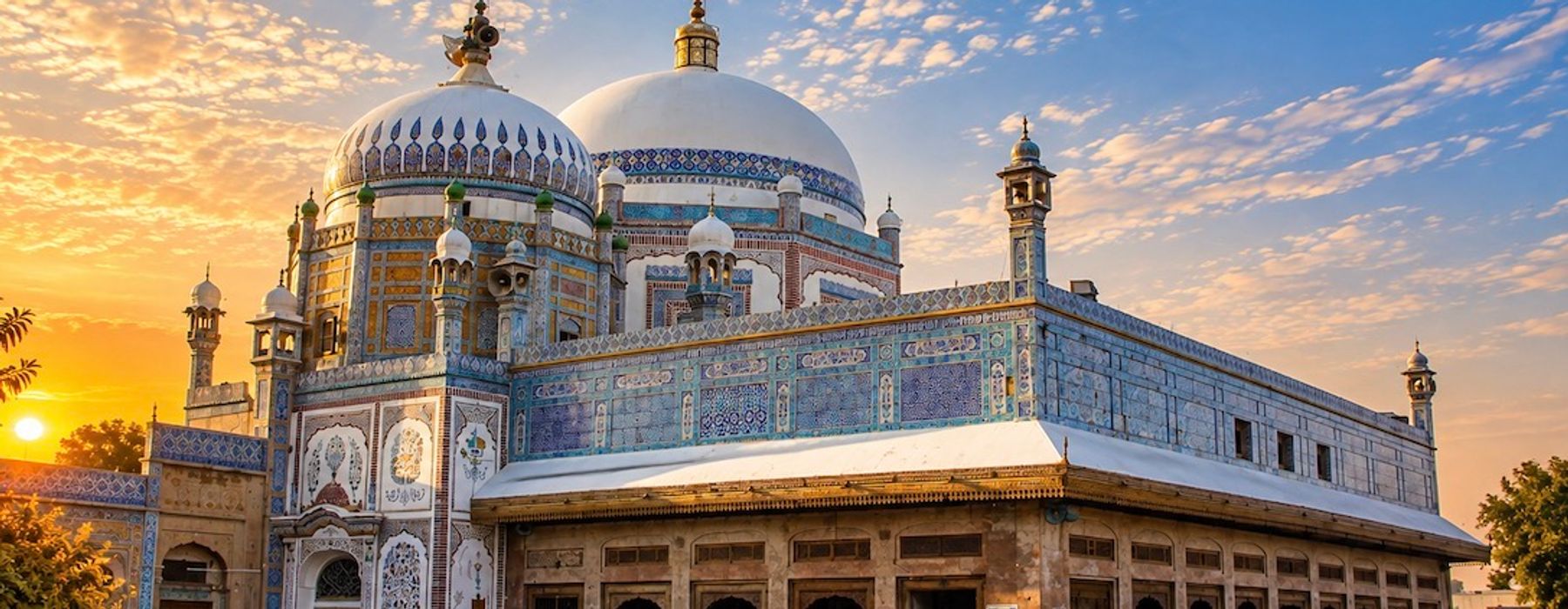
Kot Mithan is one of the most important historical and cultural places in Rajanpur District.
Located near the confluence of the Indus and the Chenab, Kot Mithan has long been associated with trade, river transportation, religious scholarship and Sufi culture.
The town is particularly famous for its association with Khwaja Ghulam Farid, one of the most important poets of Saraiki literature.
KHWAJA GHULAM FARID
Khwaja Ghulam Farid's connection with Kot Mithan gives the town a special place in Saraiki literary and spiritual heritage.
The shrine of Khwaja Ghulam Farid is located at Kot Mithan and attracts devotees and visitors from across Pakistan.
His poetry of the Rohi, desert landscapes, love, spirituality and divine longing remains deeply influential in Saraiki literature.
Every year, large numbers of devotees visit Kot Mithan for the annual Urs of Khwaja Ghulam Farid.
ROJHAN
Rojhan is one of the three tehsils of Rajanpur District.
The area lies close to the Sulaiman Mountains and is historically associated with the Mazari Baloch tribe.
Rojhan's landscape combines agricultural settlements, riverine areas and the foothills of the mountain range.
JAMPUR
Jampur is another major tehsil of Rajanpur.
It is an important agricultural and commercial centre and lies near the foothills of the Sulaiman Range.
The surrounding region contains fertile agricultural land, historic settlements and remnants of older civilizations.
DILLU ROY THERRE
Dillu Roy Therre is an ancient archaeological mound located near Jampur.
The ruins are regarded by the district administration as evidence of the area's long history of settlement and cultural development.
The site is associated with the remains of an ancient settlement and forms part of Rajanpur's archaeological heritage.
HARRAND FORT
Harrand Fort is one of the best-known historical landmarks of the district.
The fort is located in the tribal area near the Sulaiman Range and has historically served as a military position controlling routes through the region.
The site was occupied and strengthened during different periods, including Sikh and British rule.
Harrand Fort remained an important military post during the British period until the creation of Pakistan.
THE INDUS RIVER
The Indus is one of the defining geographical features of Rajanpur.
The river flows along the eastern side of the district and has historically served as an important route for trade, transportation and settlement.
The river also creates fertile floodplain areas known locally as Kacha or Selaba.
When floodwater recedes, it leaves behind fresh sediment that can improve the fertility of agricultural land.
KACHA AREA
The riverine belt along the Indus is locally known as Kacha or Selaba.
Agriculture in this area depends heavily on the river's seasonal water and flood patterns.
The Kacha landscape contains farmland, river channels, vegetation, villages and wildlife habitats.
PACHAD
The western part of Rajanpur is traditionally known as Pachad, a Saraiki term meaning the western or foothill area.
Pachad lies between the cultivated plains and the Sulaiman Mountains.
Unlike canal-irrigated areas, much of Pachad has traditionally depended on rainfall and hill-torrent water for agriculture.
SULAIMAN MOUNTAINS
The Sulaiman Range dominates the western landscape of Rajanpur.
The mountains consist of rugged ridges, valleys and dry slopes.
Rain falling in the mountains flows rapidly toward the plains through natural channels and hill torrents.
These mountains have shaped the economy, culture, settlement patterns and traditional irrigation systems of western Rajanpur.
ROD-KOHI
Rod-Kohi is one of the most distinctive traditional irrigation systems of the Rajanpur and Dera Ghazi Khan region.
The term refers to water flowing from the mountains through hill torrents into the plains.
Local communities have historically constructed embankments, diversion channels and small structures to direct this seasonal water toward agricultural fields.
Rod-Kohi agriculture demonstrates the close relationship between mountain rainfall and farming in the region.
HILL TORRENTS
Hill torrents are an essential part of Rajanpur's environment.
Streams descending from the Sulaiman Mountains can provide valuable water for agriculture, but intense rainfall can also produce destructive flash floods.
Kaha, Chachar and other major hill torrents have historically affected communities and farmland in the district.
The severe floods of 2022 demonstrated the scale of this environmental risk.
AGRICULTURE
Agriculture is one of the main sources of livelihood in Rajanpur.
The district contains several agricultural zones, including riverine land, canal-irrigated areas, well-irrigated land and rain-fed foothill agriculture.
Wheat, cotton, sugarcane and other crops are cultivated across different parts of the district.
MANGOES & ORCHARDS
Mango cultivation is an important part of Rajanpur's agricultural economy.
Tube-well irrigation has allowed orchards to develop in areas where canal water is limited.
Mango gardens and citrus orchards form part of the agricultural landscape around several settlements.
LIVESTOCK
Livestock is central to rural life, particularly in the foothill and tribal areas.
Cattle, buffaloes, goats, sheep and other animals provide food, income and agricultural support.
Animal husbandry is especially important for communities living in areas where crop production is limited by terrain or water availability.
TRIBAL HERITAGE
Rajanpur has a strong tradition of tribal social organization.
Baloch tribes have historically played an important role in the social and cultural life of the district.
Tribal identities, traditional leadership structures, customary practices and community relationships remain important aspects of local heritage.
The mountain and foothill areas contain communities whose lifestyles have historically been adapted to the rugged environment.
SARAiki LANGUAGE & IDENTITY
Saraiki is an important language of Rajanpur.
The 2023 Pakistan Census recorded 1,781,906 residents of Rajanpur District reporting Saraiki as their mother tongue, out of a total district population of 2,323,980.
Saraiki is widely used in homes, markets, villages, poetry, folk music and everyday communication.
The district's language and cultural traditions connect it with the wider Saraiki region stretching across southern Punjab and adjoining parts of Sindh and Balochistan.
SUFI HERITAGE
Rajanpur is one of the important centres of Sufi heritage in the Saraiki region.
Kot Mithan, Hajipur and other towns contain shrines associated with prominent spiritual figures.
These shrines function as religious, cultural and social gathering places.
HAJIPUR
Hajipur is associated with the shrine of Khwaja Noor Muhammad Narowala.
The shrine attracts devotees, particularly during the annual Urs.
The tradition of visiting shrines and participating in Urs gatherings forms an important part of the spiritual culture of the region.
FAZILPUR
Fazilpur is an important settlement near the centre of the district.
It is associated with the shrine of Pir Chan Charagh Shah, also known locally as Ghorrey Shah Sain.
The town is also an agricultural and commercial centre serving surrounding communities.
FOLK MUSIC
Saraiki folk music is deeply connected with Rajanpur's cultural life.
Traditional forms including kafi, dohra and folk songs are performed at weddings, religious gatherings, cultural events and family celebrations.
The musical traditions of the district share close connections with the wider folk culture of Dera Ghazi Khan, Muzaffargarh, Layyah, Multan and Bahawalpur.
POETRY
Rajanpur's greatest literary association is with Khwaja Ghulam Farid.
His poetry transformed the landscapes of the Rohi and southern Punjab into powerful literary images.
The desert, rivers, mountains, separation, love and spiritual longing remain recurring themes in Saraiki poetic expression.
ORAL TRADITIONS
Stories, legends, poetry and folk memories have traditionally been passed from one generation to another.
Mountain communities, farmers, shepherds, poets and religious figures have all contributed to the preservation of local oral traditions.
TRADITIONAL DRESS
Traditional clothing reflects the wider cultural traditions of southern Punjab and the adjoining Baloch areas.
Men commonly wear shalwar kameez, while turbans and regional styles remain particularly visible in rural and tribal communities.
Women wear colourful shalwar kameez and embroidered clothing, with styles varying between communities.
HANDICRAFTS
Traditional embroidery, woven textiles and handmade decorative work form part of the rural cultural economy.
Craft traditions reflect both the Saraiki plains and the tribal communities of the western foothills.
FOOD CULTURE
Rajanpur's cuisine reflects its agricultural, pastoral and riverine environment.
Traditional foods include wheat breads, rice dishes, vegetables, pulses, meat and dairy products.
Mangoes, dates and other locally grown fruits also contribute to the region's food culture.
CLIMATE
Rajanpur has a hot and generally dry climate.
The plains experience very hot summers, while the mountain areas have different local conditions because of elevation.
Rainfall is particularly important because mountain precipitation feeds the hill torrents that provide water to parts of the foothill agricultural zone.
FLOODS
Rajanpur faces two major types of flooding.
The eastern Kacha areas can experience flooding from the Indus River, while the western foothill areas are vulnerable to flash floods generated by intense rainfall in the Sulaiman Mountains.
The 2022 floods were particularly severe, with torrential flows from major hill torrents affecting large areas of the district.
This makes flood management and early-warning systems important parts of life in Rajanpur.
NATURAL ENVIRONMENT
The district contains a remarkable variety of landscapes.
These include the Indus floodplain, agricultural fields, Kacha forests, Pachad foothills, mountain valleys and rugged Sulaiman slopes.
This environmental diversity supports different forms of agriculture, livestock raising and wildlife.
WILDLIFE
The riverine and mountain environments support a variety of birds and other wildlife.
The Indus floodplain provides habitats for waterbirds and other species, while the mountain and foothill areas support animals adapted to dry and rugged environments.
Conservation of these habitats remains important as agricultural expansion and climate pressures increase.
EDUCATION
Education has expanded across Rajanpur through government schools, colleges and private educational institutions.
Schools and colleges serve the three tehsils as well as rural and tribal communities.
Students also travel to Dera Ghazi Khan, Multan and other cities for higher education and professional studies.
HEALTHCARE
Rajanpur District has hospitals, rural health centres, basic health units and other public and private healthcare facilities.
Healthcare access remains particularly important in remote mountain and tribal areas where settlements can be widely dispersed.
TRANSPORT & CONNECTIVITY
Rajanpur is connected by road with Dera Ghazi Khan, Multan, Rahim Yar Khan and other parts of southern Punjab.
Road connections also link the district with Sindh and Balochistan.
The Indus historically served as a major transportation and trade route, while modern roads have become the principal means of regional connectivity.
ECONOMY
Agriculture remains one of the foundations of the district economy.
Other important activities include livestock, trade, food processing, cotton-related activities, transport, public services and small-scale commerce.
The economy varies considerably between the irrigated plains, riverine areas and mountain foothills.
ARCHAEOLOGICAL HERITAGE
Rajanpur contains archaeological sites and ancient settlement mounds that demonstrate the long history of human habitation in the region.
Dillu Roy Therre, the old remains around Jampur and other archaeological locations provide evidence of earlier settlements and cultural activity.
These sites form an important part of the district's historical heritage.
MODERN RAJANPUR
According to the 2023 Census, Rajanpur District had a population of 2,323,980.
Today the district continues to develop through agriculture, education, healthcare, roads, public services and commercial activity.
Despite modern development, traditional relationships with the Indus, mountains, agriculture, language and tribal communities remain important.
RAJANPUR & SARAIKISTAN
Rajanpur occupies a distinctive place within Saraikistan.
It is a region where the Saraiki plains meet the Sulaiman Mountains, where the Indus meets the agricultural Kacha belt, and where ancient settlements exist alongside living tribal and Sufi traditions.
Its connection with Khwaja Ghulam Farid gives it an especially important place in Saraiki literature and spiritual culture.
From the shrine of Khwaja Ghulam Farid at Kot Mithan to the rugged Sulaiman Range, from Rod-Kohi agriculture to the banks of the Indus, Rajanpur represents a diverse and living part of Saraiki heritage.
Rajanpur is a region of rivers, mountains, poetry, spirituality, agriculture and enduring cultural traditions.